


Becker County is located in west central Minnesota, 30 miles east of the Fargo/Moorhead MSA. Established by an act of the legislature, Becker county was approved on March 18, 1858. The county is situated in the heart of what is known as Park Region and is considered one of the state’s most beautiful and versatile recreation areas. The county contains more than 400 lakes and encompasses 11 communities, including the county seat, Detroit Lakes. It encompasses 1440 square miles, divided into 37 townships, and stretches 30 miles north to south and 48 miles east to west. It is the only Minnesota county containing all the Minnesota state symbols: loons, pink and white lady slippers, wild rice, Norway Pines, blueberries and eagles.
Becker County was named for Brigadier General George Loomis Becker of St. Paul. in 1857, when Minnesota was a new state, Becker was one of three men elected as members of Congress. Minnesota could only send two, so Becker stayed in Minnesota, and authorities promised him they would name the next county after him. Thus, when the county was formed, it was named Becker after the General.
_______________________________________________________________________
Becker County Coalition Of Lake Associations
The mission of the Coalition of Lake Associations (COLA) is to facilitate cooperation among the member Lake Associations to protect and enhance the quality of lakes and their shore areas.
Since its founding in 1991, COLA has compiled an impressive history of advocating for preservation of the public waters by participating in formation of the Becker County Comprehensive Plan, updating the Becker County Shore land Management Ordinance, serving on County Committees and representing Lake Association interests before the Planning Commission, Board of Adjustment and County Commission
The Coalition has a three-tiered organizational structure. First, the Lake Association members are the foundation of the Coalition. Second, each affiliated Lake Association elects or appoints a Representative to serve as a liaison and Board member of the Coalition. Third, the Officers of the Coalition are in turn elected by the COLA Representatives.
https://www.co.becker.mn.us/our_county/default.aspx
_______________________________________________________________________
_______________________________________________________________________
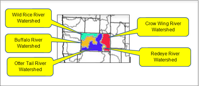
Wild Rice River Watershed District
The Wild Rice Watershed District exists to manage water flow in the drainage area of the Wild Rice River in northwestern Minnesota. The Wild Rice Watershed District includes areas of Norman, Mahnomen, Clay, Polk, Clearwater, and Becker counties.
The Wild Rice Watershed District:
- Issues permits for water related drainage
- Maintains Watershed Drainage Ditches
- Maintains Watershed Projects
- Prevents erosion into surface waters
- Protects fish and wildlife habitat
- Protects groundwater and surface water systems
- Improves water quality
- Establishes governmental policies to manage water resources
- Provides recreational opportunities
Crow Wing River Watershed
The Crow Wing River Watershed is located in north-central Minnesota and covers approximately 1,946 square miles within Becker, Cass, Clearwater, Crow Wing, Hubbard, Morrison, Otter Tail, Todd, and Wadena Counties. The watershed is located in the Upper Mississippi River Basin and is comprised of two ecoregions: the Northern Lakes and Forests, and North Central Hardwood Forests.
Land use within the watershed is primarily forested/shrub lands, followed by agricultural lands, wetlands, open water, and developed lands. Municipalities located within the Crow Wing River Watershed include Akeley, Menahga, Nevis, Nisswa, Osage, Park Rapids, Pequot Lakes, Ponsford, and Staples. There are a large number of pristine, high-value recreational lakes in the Crow Wing River Watershed and several cold water streams that support trout are located in the watershed.
The Crow Wing River watershed includes over 627 lakes 10 acres in size or greater as well as 1,653 stream and river miles. The Crow Wing River flows into the Mississippi River at Crow Wing State Park. Land use in the Crow Wing River watershed is mostly forested and agriculture.
There are a large number of pristine, high-value recreational lakes in the Crow Wing River Watershed and several cold water streams that support trout are located in the watershed. A handful of lakes and a few tributaries do not meet water quality standards for beneficial uses such as aquatic recreation, drinking, and swimming. The main lake pollutant is phosphorus, causing algae blooms in summer months.
Redeye River Watershed
The Redeye River watershed covers 575,366 acres (899 square miles) and is located the northwestern to north-central part of the Upper Mississippi River Basin in central Minnesota. The watershed encompasses all or parts of Becker, Otter Tail, Todd, and Wadena counties. The Redeye River begins at Wolf Lake and travels south where it joins the Leaf River and eventually joins the Crow Wing River north of Staples.
The Redeye River watershed has approximately 633 total river miles, of which 316 miles of rivers are considered perennial. The major rivers within this watershed include the Red Eye, the Leaf, and the Wing. There are 11 creeks and 7 county ditches, as well as numerous smaller flowages. The watershed contains approximately 126 lakes covering 8,228 acres.
The majority of the watershed is within the North Central Hardwood Forest with a small sections in the Northern Lakes and Forests ecoregion. Nearly half the watershed’s land use is agricultural, 30% is forested, 15% is wetlands, and about 4% is developed communities and industries.
_______________________________________________________________________
The mission of the Becker SWCD is to develop and promote long range programs that satisfy the conservation needs of the people of the District. With rapidly expanding interests in resource development, it is essential that proper resource management be carried out in the District. The programs will include, but not be limited to proper treatment of each acre of land in Becker County in accordance with its needs. Emphasis will be placed on wind and water erosion and protection practices. Implementation of the Comprehensive Local Water Plan will be administered by the District as well as serving as the Local Government Unit for the 1991 Wetland Conservation Act. Technical assistance is provided by the USDA Natural Resource Conservation Service (NRCS).