


The Crow Wing River flows east-southeast along Cass County’s southern border, and the Gull River flows southwest through the lower part, to discharge into the Crow Wing on the southern border. The terrain consists of wooded rolling hills, heavily dotted with lakes and ponds, and slopes to the south and east; its highest point is on the upper western border.
_______________________________________________________________________
Association of Cass County Lake Associations
The ACCL and its 35+ lake association members are volunteers that donate countless hours to promote the well-being of our lakes. ACCL also promotes working with our partners which include Cass County Environmental Services, Cass County Soil and Water, Leech Lake Band of Ojibwe, Northern Waters Land Trust, MN DNR, MN Pollution Control Agency, RMBEL Environmental Labs, and the MN Aquatic Invasive Research Center. The ACCL Newsletter is sent to the elected officials in Cass County, including all 50 townships. We also send invitations and newsletters to our state officials. By creating a web of connection, we are also creating a web of education and idea sharing. To fully protect and preserve our waters, we must work together.
_______________________________________________________________________
Environmental Services Department is responsible for all of the following activities:
- Coordinating the overall administration of environmental service programs for the county.
- Developing and maintaining environmental programs.
- Planning, directing, coordinating, and evaluating all planning and zoning activities, as well as environmental health related programs and services.
- Overseeing all solid waste management activities of the county, including the recycling program, licensure of private waste haulers, transportation, and processing.
Cass County Environmental Services Department
Cass County Soil & Water
Water Quality Information
_______________________________________________________________________
Leech Lake Band Of Ojibwe Environmental Lands Department
The Water Resources Program is responsible to ensure that the future of the Band’s water resources are preserved and retain the quality and quantity necessary to continue practicing the inherent traditional, cultural and spiritual ways of life of the people which are also protected by Treaties with the United States Government. Funding for these activities is authorized by Section 106 of the Clean Water Act. The Clean Water Act of 1972 was developed to address growing environmental and public health concerns related to water pollution. The act created mechanisms to regulate discharge of pollutants and to ensure appropriate water quality.
Leech Lake Band Of Ojibwe Division Of Resource Management
_______________________________________________________________________
The Northern Waters Land Trust [formerly the Leech Lake Area Watershed Foundation] is a non-profit charitable 501(c)(3) organization working in north central Minnesota in the Counties of Aitkin, Cass, Crow Wing, and Hubbard. We work to preserve land in order to protect water quality and preserve environmentally sensitive shoreland, streams, fish and wildlife habitats, wetlands, key forest tracts, and scenic vistas.
Our conservation efforts focus on an area that encompasses 6 major watersheds. Our service area is nearly 4.2 Million acres and includes 2,235 lakes and 3,400 miles of streams and rivers. It is an incalculable beauty, rich in natural resources with a high degree of biodiversity. This region is home to the headwaters of the Mississippi River and is the source water for communities downstream including St. Cloud and the Twin Cities.
_______________________________________________________________________

_______________________________________________________________________
Cass County Watersheds
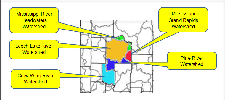
Mississippi Headwaters Watershed
Approximately 44% of the land in this watershed is privately owned, with the remaining portion of land state, county or federal public land, or held by tribal land owners. Agricultural land use within the watershed is moderate, accounting for approximately 10% of the available acres.
Groundwater springs are present throughout much of the river channel throughout this watershed. These springs are especially common above Lake Bemidji where groundwater contributes approximately two-thirds of the Mississippi River’s flow in this section. This watershed is rich in surface water resources, including some of Minnesota’s most famous lakes and streams. Each year, thousands of anglers travel to this watershed in search of walleye and other game fish.
Currently, the vast majority of the surface water resources within this watershed meet Minnesota’s surface water quality standards for conventional parameter pollutants (not including mercury). However, these resources continue to experience increased pressure from development and subsequent loss of shoreline and aquatic habitat. The threat of aquatic invasive species is also a primary concern for local partner groups, conservation groups, and the citizens within this watershed.
The major threats to the watershed include:
- Loss of shoreline and aquatic habitat due to development. Many of the prime lakeshore properties have been developed with the focus of development turning toward more marginal shoreland and/or shoreland along smaller natural environmental water resources.
- Increased sedimentation due to forest management practices.
- Increased nutrient, contaminant, and sedimentation loading from stormwater runoff from development and other non-point sources.
- Loss of biodiversity due to competition from invasive species.
Mississippi Headwaters Watershed
Leech Lake River Watershed
The Leech Lake River watershed consists of approximately 854,659 acres (1,335 sq. miles) in the northern part of the Upper Mississippi River Basin. The watershed includes parts of Beltrami, Cass, and Hubbard counties. Major communities in the watershed are Laporte, Benedict, Walker, Federal Dam, Boy River, Whipholt, Longville, and Hackensack. The watershed also includes the Leech Lake Reservation (Leech Lake Band of Chippewa). The Leech Lake River watershed has 277 total river miles and contains over 750 lakes with a total acreage of 166,374.
The Leech Lake River watershed is situated in the heart of Minnesota’s lake country and contains some of the most pristine natural resources in Minnesota. This watershed has a very high degree of biodiversity in its thousands of acres of forests and surface waters. One-half of Minnesota’s naturally producing Muskie lakes and a quarter of the natural Muskie habitat in the U.S. is located in the watershed.
Currently, the surface water resources within this watershed meet Minnesota’s water quality standards for conventional pollutants (not including mercury). However, these resources are experiencing increased pressure from development and subsequent loss of shoreline and aquatic habitat. The surface water resources within this watershed are highly prized for their recreational value and these resources attract several hundred thousand vacationers to the area each year. The protection of these resources is vital in sustaining the local economy and natural heritage and character of this watershed.
The major threats to the watershed include:
- Loss of shoreline and aquatic habitat due to development.
- Population growth of up to 60% projected for the watershed by 2030, according to Minnesota State Demographers.
- Increased nutrient, contaminant, and sedimentation loading from stormwater runoff from development and other non-point sources.
- Loss of biodiversity due to competition from invasive species.
Leech Lake River Watershed
Crow Wing River Watershed
Land use within the watershed is primarily forested/shrub lands, followed by agricultural lands, wetlands, open water, and developed lands. Municipalities located within the Crow Wing River Watershed include Akeley, Menahga, Nevis, Nisswa, Osage, Park Rapids, Pequot Lakes, Ponsford, and Staples. There are a large number of pristine, high-value recreational lakes in the Crow Wing River Watershed and several cold water streams that support trout are located in the watershed.
The Crow Wing River watershed includes over 627 lakes 10 acres in size or greater as well as 1,653 stream and river miles. The Crow Wing River flows into the Mississippi River at Crow Wing State Park. Land use in the Crow Wing River watershed is mostly forested and agriculture.
There are a large number of pristine, high-value recreational lakes in the Crow Wing River Watershed and several cold water streams that support trout are located in the watershed. A handful of lakes and a few tributaries do not meet water quality standards for beneficial uses such as aquatic recreation, drinking, and swimming. The main lake pollutant is phosphorus, causing algae blooms in summer months.
Mississippi Grand Rapids Watershed
Located in the north central region of Minnesota, the Mississippi River – Grand Rapids Watershed drains more than 1.3 million acres of land from the Laurentian Continental divide to the Mississippi River near the city of Palisade. It crosses through the counties of Aitkin, Cass, Carlton, Itasca, and St. Louis and sustains many valuable resources throughout its expanse. It is home to the communities of Grand Rapids (pop. 10,866), McGregor (390), and Remer (370), among many others.
The watershed maintains around 2,000 miles of streams and rivers and 625 lakes larger than 10 acres. Of these lakes, 79 produce wild rice, a unique resource that Minnesota produces more of than any other state, and 48 are cold water fisheries, beneficial to supporting healthy trout populations in the watershed. These beautiful lakes make the watershed an attractive destination for recreation. Forest land makes up most of the watershed (56%), providing many excellent ecosystem services such as water filtration and habitat for diverse species.
Mississippi Grand Rapids Watershed
Pine River Watershed
The Pine River watershed is approximately 502,400 acres in size. The watershed drainage for the Pine River contains parts of Aitkin, Cass, Crow Wing and Hubbard counties. Pine River and Crosslake are the major cities in the watershed.
The Pine River watershed contains 586 stream and river miles of various sizes, and 441 lakes greater than 10 acres. Land ownership in the Pine River Watershed is 56% privately held and over 40% is state-owned land. The watershed is 51% forested, 21% wetlands, and 13% open water. The watershed contains numerous heavily developed lakes. The majority of the lakes are important recreational resources and economic benefits to the watershed.
Several lakes are impaired for aquatic consumption (mercury).