


Otter tail County is located in West Central Minnesota, USA. It is home to over 1,000 lakes, more than any other County in the USA, covering over 150,000 acres (11% of the County).
![]()
Otter Tail County Coalition Of Lake Associations
OTC COLA has over 50 Member Lake Associations representing close to 60 lakes (70% of the lake acreage in the County). The Water Quality Analysis Program has been in existence over 20 years providing running 10-year trend analysis reports.
OTC COLA partners with Lake Associations sponsoring water quality testing programs, communications, education and legislative forums. OTC COLA maintains strategic alliances with lake and river organizations, government lobbyists and State and County government officials.
OTC COLA Water Quality Analysis Reports
______________________________________________________________________
![]()
It is the Mission of the Otter Tail County Aquatic Invasive Species Task Force to develop programs and strategies to support and enhance the protection of Otter Tail County waters. In order to accomplish this, the Task Force will promote public awareness, education, containment, research and provide recommendations to the Otter Tail County Board of Commissioners.
https://ottertaillakescountry.com/aquatic-invasive-species-task-force/
______________________________________________________________________
Watersheds in Otter Tail County
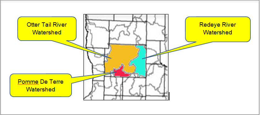
Otter Tail River Watershed
https://www.pca.state.mn.us/water/watersheds/otter-tail-river
“The mission of the PDTRA is to protect and improve the surface and ground water resources of the Pomme de Terre River Watershed by addressing water quality and quantity issues while also promoting healthy and sustainable agriculture, industrial, and recreational based economy for the region.”
https://www.pdtriver.org/
Redeye River Watershed
The Redeye River watershed covers 575,366 acres (899 square miles) and is located the northwestern to north-central part of the Upper Mississippi River Basin in central Minnesota. The watershed encompasses all or parts of Becker, Otter Tail, Todd, and Wadena counties. The Redeye River begins at Wolf Lake and travels south where it joins the Leaf River and eventually joins the Crow Wing River north of Staples.
The Redeye River watershed has approximately 633 total river miles, of which 316 miles of rivers are considered perennial. The major rivers within this watershed include the Red Eye, the Leaf, and the Wing. There are 11 creeks and 7 county ditches, as well as numerous smaller flowages. The watershed contains approximately 126 lakes covering 8,228 acres.
The majority of the watershed is within the North Central Hardwood Forest with a small sections in the Northern Lakes and Forests ecoregion. Nearly half the watershed’s land use is agricultural, 30% is forested, 15% is wetlands, and about 4% is developed communities and industries.
______________________________________________________________________
Otter Tail County Townships
______________________________________________________________________
Soil & Water Conservation Districts
East Otter Tail Soil & Water Conservation District
SWCDs are governed by a board of locally elected supervisors that develop policy, plans, and budgets for the district, empower and work with staff, and represent the district at meetings and other events. SWCD staff work primarily in a one-on-one basis with landowners, aiming to connect landowners with the technical and financial resources they need to put conservation practices on the land. Other conservation partners include local businesses, schools, cities, townships, lake associations, and state and federal agencies. Otter Tail County has two SWCDs that work jointly on many efforts, please contact your local office for assistance.
https://www.eotswcd.org/
West Otter Tail County Soil & Water Conservation District
The West Otter Tail Soil and Water Conservation District is a local unit of government that is supervised by a board of five elected officials. SWCD’s were created as a result of the dust bowl era to help private landowners incorporate best management practices on their land. The SWCD focuses on local assistance which ranges from working with individual landowners to federal agencies along with other units of government such as counties, cities, townships and watershed districts. The SWCD offers many services such as technical and financial assistance, project design and installation of conservation practices.
SWCDs are governed by a board of locally elected supervisors that develop policy, plans, and budgets for the district, empower and work with staff, and represent the district at meetings and other events. SWCD staff work primarily in a one-on-one basis with landowners, aiming to connect landowners with the technical and financial resources they need to put conservation practices on the land. Other conservation partners include local businesses, schools, cities, townships, lake associations, and state and federal agencies. Otter Tail County has two SWCDs that work jointly on many efforts, please contact your local office for assistance.